Introduction

Lithuania is situated on the eastern shore of the Baltic Sea. Lithuania lies at the edge of the East European Plain. Its landscape was shaped by the glaciers of the last Ice Age. Lithuania's terrain is an alternation of moderate lowlands and highlands.The highest elevation is 297 meters above sea level, found in the eastern part of the republic and separated from the uplands of the western region of Samogitia by the very fertile plains of the southwestern and central regions.
Lithuania's territory today consists about 30 percent woodlands - mainly pine, spruce, and birch forests. Ash and oak are very scarce. The forests are rich in mushrooms and berries. There is 4 National parks (Aukstaitija national park, Dzukija national park, Zemaitija national park, Kursiu Nerija national park) and 30 smaller regional parks.
The country's climate, which ranges between maritime and continental, is relatively mild. Average temperatures on the coast are 1.6°C in January and 17.8°C in July. In Vilnius the average temperatures are 2.1°C in January and 18.1°C in July. Average annual precipitation is 717 millimeters on the coast and 490 millimeters in the eastern part of the country.
The landscape is punctuated by 2,833 lakes larger than one hectare and an additional 1,600 ponds smaller than one hectare. The majority of the lakes are found in the eastern part of the country. Lithuania has 758 rivers longer than 10 kilometers. The largest river is the Nemunas (Memel, Neman) (total length 917 kilometers, in Lithuania 475 kilometers), which originates in Belarus . The other larger waterways are the Neris (Vilija) (510 kilometers, in Lithuania 234 kilometers), Venta (346 kilometers, in Lithuania 161 kilometers), and Sesupe (298 kilometers, in Lithuania 220 kilometers) rivers.
Lithuania rivers mostly is flatwater (average gradient 0.05 - 0.7 m/km) and can be paddled all year. Some bigger rivers (the Minija, the Jura etc.) also some smaller rivers (the Akmena, the Ancia, the Sirvinta etc.) (average gradient 1.0 - 5.5 m/km) and brooks (the Duksta, the Zvelsa etc.) (average gradient up to 15 m/km) have white water sections up to Grade 2+ and can be paddled only at higher water level at spring flood or after heavy rains. Most suitable boat to discover rivers of Lithuania is kayak or canoe.
This web site has been written to be used as a tool for people seeking recreational information on the river opportunities within the country. As with any guide please take the information at face value and use judgment in planning your trips.
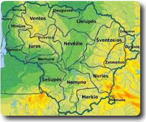
There are approximately 150 runs described on this site. An effort was made to cluster each river into one of several geographic regions and main rivers basins. You can search on left side for a specific river by choosing it’s region or river basin (above is an interacive map) or by typing the river name into the search box.
Here you find some information about places to stay, campsites, kayak and canoe rentals.


